Consultation Process
Now Closed
This online engagement was hosted on YourSAy from 14 October to 25 November 2019. Below is a record of the engagement.
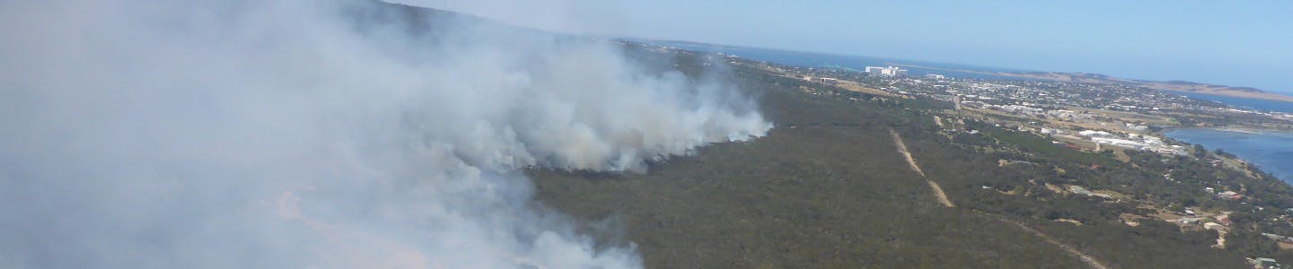
Help us reduce bushfire risk on the Lower Eyre Peninsula and tell us what you think of the draft Lower Eyre Peninsula Bushfire Management Area Plan.
What is being decided?
The Lower Eyre Peninsula Bushfire Management Area Plan (BMAP) identifies communities, facilities, infrastructure and environmental assets at risk from bushfire. The BMAP allows the Bushfire Management Committee to assess the bushfire risks across the region and determine appropriate prevention strategies to reduce those risks.
The Lower Eyre Peninsula BMAP comprises three parts:
- A pdf document Draft Bushfire Management Area Plan - outlining the planning process, content and other relevant information
- An interactive web-based map that identifies assets and their risk levels, and includes pop-up tables of information for each asset
- A spreadsheet Asset Treatment List containing a list of all BMAP assets, their risk rating and activities to help mitigate the risks.
All documents can be viewed on the LEP BMAP webpage.
This is the four-yearly review of this plan and many meetings with key stakeholders and government agencies have been undertaken to add, revise and correct information, however we would like to hear from all members of the public impacted by this plan.
Get involved
Learn more about the Lower Eyre Peninsula Bushfire Management Area Plan and view the FAQs
CFS Bushfire Management Planning Unit
Postal PO Box 2468
ADELAIDE SA 5001
All submissions will be publicly available to anyone who requests a copy. Please let us know if you don't want your input on the public record.
How can your input influence the decision?
Community input will assist the Bushfire Management Committee members to finalise the BMAP. Your feedback will help improve bushfire safety across the Lower Eyre Peninsula.
What are the next steps?
Written responses will be provided to those who make a submission and all feedback will be considered and if appropriate, incorporated into the LEP BMAP.
The final Draft will be submitted to the State Bushfire Coordination Committee to be formally approved. The approved LEP BMAP will be published on the CFS website.
The Bushfire Management Committee will then work with government agencies to implement the treatment strategies.
Contact
For more information about the bushfire management planning process:
Closing date: 5pm, Monday 25 November 2019
Background
Now Closed
This online engagement was hosted on YourSAy from 14 October to 25 November 2019. Find out more about the consultation process. Below is a record of the engagement.
Bushfire is a natural part of the South Australian landscape. South Australia experiences bushfires every fire season. A serious destructive fire will occur somewhere in the State in 6 or 7 years out of every 10. A bushfire can cause injury and loss of human life. It can damage or destroy property if it is able to flare up and travel through the landscape.
Understanding bushfire risk to people and property means you can take appropriate actions to prevent damage.
The State Bushfire Co-ordination Committee (SBCC) is responsible for bushfire management planning in SA. The Committee has divided the State into 9 Bushfire Management Areas. There is a sub-Committee, Bushfire Management Committee (BMC), for each area. The BMC will prepare a Bushfire Management Area Plan (BMAP) for its area.
Bushfire Management Area Plans identify the risks and actions individuals organisations can take to reduce bushfire risk. These plans were developed as part of a project funded by the Natural Disaster Resilience Program in partnership with the Commonwealth and State Government of South Australia.
The 9 Bushfire Management Areas are:
- Adelaide and Mount Lofty Ranges
- Fleurieu
- Flinders, Mid North and Yorke Peninsula
- Kangaroo Island
- Limestone Coast
- Lower Eyre Peninsula
- Murray Mallee
- Outback
- Upper Eyre Peninsula
This is the first BMAP to undergo a four-yearly review. During this review all assets and treatments have been revised with several new assets added.
This will be the second of the Bushfire Management Area Plans (BMAPs) to display the risk assessment for environmental assets at risk from bushfire, under the new methodology developed by the Ecological Technical Reference Group (a Working Group of the State Bushfire Coordination Committee).
It's important to understand that BMAPs are directed at Prevention and Preparedness. They do not include bushfire incident or disaster management, response or recovery issues such as what to do during a bushfire or where to get help after a bushfire. These issues are covered in other plans, policies and procedures of government and non-government emergency and community service agencies.