
FAQs
Riverbank Precinct Code Amendment
- Rezoning land west of the Royal Adelaide Hospital from the Adelaide Park Lands Zone to City Riverbank Zone (Health Subzone) to support the development of the new Women’s and Children’s Hospital.
- Rezoning land west of Montefiore Rd from Adelaide Park Lands Zone to City Riverbank Zone (Entertainment Subzone) and a portion of land already in City Riverbank Zone from Health Subzone to Entertainment Subzone. This will support the development of entertainment-related uses, such as an arena.
- Rezoning land near and on which the Adelaide Botanic High School currently sits, from Adelaide Park Lands Zone to City Riverbank Zone (Innovation Subzone), to better reflect current use.
- Applying a new Riverbank Subzone in the Adelaide Park Lands Zone to the southern and northern side of the River Torrens in the location between Kintore Avenue and the Torrens Weir to accommodate appropriate small-scale development such as cafes and shops (both on-water and off-water) that contributes to the activation of the riverfront, in a way that protects the open landscaped character and heritage values of Elder Park.
- Policy changes to support connections and linkages throughout the precinct.
- Policy changes to support development of high quality and amenity.
What is a Code Amendment?
The Planning and Design Code (the Code) contains the planning rules and policies that guide what can be developed in South Australia. Planning authorities use these planning rules to assess development proposals.
A Code Amendment is a proposal to change the policies, rules or mapping within the Code, which can change the way that future developments are assessed. This process is often referred to as a rezoning.
Code Amendments must be prepared according to certain processes set out by legislation (the Planning, Development and Infrastructure Act 2016 and associated Regulations).
Code Amendments may be undertaken by a range of entities including the State Planning Commission, councils, state agencies, people who have an interest in land, or the Chief Executive of the Attorney-General’s Department. This Code Amendment has been prepared by the Chief Executive of the Attorney-General’s Department.
Why do we need this Code Amendment?
The purpose of this proposed Code Amendment is to review planning policy in the Riverbank Precinct between North Terrace and the River Torrens in the City of Adelaide.
The Riverbank Precinct is an integral part of the city’s identity and a major contributor to its overall vibrancy. The Code Amendment seeks to ensure South Australians can enjoy the Riverbank for generations to come.
The Code Amendment will support the development of the new Women's and Children's Hospital, provide for improved accessibility and built form outcomes, greater activation of the riverbank between the Torrens Weir and Kintore Avenue and expansion of the Lot Fourteen innovation precinct, while preserving valuable green spaces, such as Elder Park.
What is being proposed?
Key features of the proposed Riverbank Precinct Code Amendment include:
New Women’s and Children’s Hospital
What area is proposed to be rezoned?
The new Women’s and Children’s Hospital (nWCH) is proposed to be built on land west of, and adjacent to the Royal Adelaide Hospital.
The new facility will include a three-storey carpark that will provide 1215 spaces and end-of-trip facilities such as secure bike storage and change room facilities for hospital staff and visitors.
Pram and disability parks will be in close proximity to the hospital, more accessible and more user-friendly than the current arrangement at the WCH. This will greatly benefit many of the most frequent users of the hospital.
One of the key design features is a new bridge, which will enable families and staff to cross from the nWCH to the hospital’s new, multi-level car park and the western park lands (Bonython Park and Kate Cocks Park) for respite and play.
To support the development of these facilities, it is proposed to rezone land currently within the Adelaide Park Lands Zone (west of the railway line) to City Riverbank Zone.
How is the proposed site currently being used?
A portion of the selected site east of Gaol Road is currently inaccessible to the public and has been used by SAPOL to graze police horses.
The remainder of the site south of Adelaide Gaol is used for car parking, and has historically been used as a storage area for construction materials and site huts.
What are the benefits of building the nWCH alongside the Royal Adelaide Hospital (RAH)?
Co-locating the nWCH next to the RAH will give women and children direct access to clinical support, including an intensive care unit. It will also provide access to the RAH’s helipad, significantly reducing the risk of transferring maternity, paediatric and neonatal emergencies.
Having both hospitals at the same location will also ensure a smoother transition for young people with long-term conditions from paediatric to adult services, and better person and family centred care facilities and services that enhance the experience for patients and families, including outdoor areas and family resource rooms.
Direct linkage to the RAH and the broader Adelaide BioMed City also provides opportunities to leverage existing infrastructure to support the nWCH in areas like engineering infrastructure, loading dock, corporate and clinical support functions where appropriate.
It is vital that these opportunities are maximised, optimising the investment in clinical care and ensuring value of the nWCH investment to the community of South Australia.
Where can I find out more about the nWCH?
Up-to-date information about the nWCH is available on the WCH website.
Expanded Entertainment Precinct
What area is proposed to be rezoned for the expanded Entertainment Precinct?
The expanded Entertainment Precinct is proposed to be situated to the west of Montefiore Road, south of the River Torrens and north of the railway line. A section of land in this area is proposed to be rezoned from Adelaide Park Lands to City Riverbank Zone, Entertainment Subzone (and a portion of land already in the City Riverbank Zone changed from Health Subzone to Entertainment Subzone). Maps of the proposed rezoning are available on the PlanSA website.
How is this area currently being used?
Much of the proposed site consists of discarded soil, work and storage yards, and car parking, with the majority of the site fenced-off to prevent public access. There is no safe public walkway to the small publicly useable area.
It is expected that expanding the Entertainment Precinct to include this area west of Montefiore Road will rejuvenate the area by supporting the development of entertainment-related uses (such as an arena) and health-related uses and make the area more publicly accessible.
How does the recently announced Adelaide Riverbank Arena fit into the precinct?
The proposed Adelaide Riverbank Arena has been identified to be located in part of the expanded Entertainment Precinct.
The arena is only a proposal at this stage and is still subject to funding and development assessment processes.
In addition to the proposed arena, the expanded Entertainment Precinct could also accommodate a diverse range of other entertainment-related and health-related uses to activate the area.
Where can I find more information about the proposed arena?
More information is on the Adelaide Venue Management website.
Police Barracks / Old Adelaide Gaol / Kate Cocks Park (Park 27)
Why is the area being rezoned?
Land encompassing the Old Adelaide Gaol, SAPOL Barracks and Kate Cocks Park is proposed to be rezoned from Adelaide Park Lands Zone to City Riverbank Zone (Health Subzone) to provide opportunities for this land to be adapted and reused in a manner that also complements the historic values and park lands setting.
The current Adelaide Park Lands Management Strategy identifies the need for this underutilised area of the park lands to be opened up to future adaptive reuse opportunities to provide a more attractive and welcoming interface with the city / park lands.
How is the site currently being used?
The area identified for rezoning is currently used as Police Barracks, driver education centre and public uses associated with the Old Adelaide Gaol. Horse keeping / agistment associated with the Police Barracks (the Police Greys) is also undertaken directly adjacent the railway corridor in the eastern part of Kate Cocks Park.
What will happen to the existing SAPOL Barracks and Old Adelaide Gaol?
There are no current plans to change the current use of the SAPOL Barracks or the Old Adelaide Gaol. The proposed rezoning seeks to deliver a policy setting that facilitates the adaptive reuse of the existing heritage-listed SAPOL Barracks and Old Adelaide Gaol.
The Code Amendment will not alter the state heritage listings and/or protections over this area but will provide more scope for future use of the land, consistent with the heritage values of the locality, through adaptive reuse.
Examples of similar adaptive reuse outcomes can be found at the Lot Fourteen Precinct (former Royal Adelaide Hospital site) located at the eastern of the Riverbank Precinct. Redevelopment of this site is improving public realm and interface with the park lands.
What will be the benefits of rezoning this area?
Rezoning this relatively underutilised area will unlock future public / private investment in infrastructure associated with the Biomedical Precinct and greater Riverbank Precinct.
Rezoning the area will provide more options for future adaptive reuse of heritage items on SAPOL Barracks and Old Adelaide Gaol site, providing for greater public access.
Adelaide Botanic High School
Why is the area being rezoned?
The Adelaide Botanic High School and surrounding land is being rezoned to better reflect the existing use of the site as an innovative school with a technology and research focus.
How is the site currently being used?
The site currently accommodates the new Adelaide Botanic High School which opened in 2019. The site also accommodates Frome Park (part) to the south which provides a dedicated open space link between Frome Road and the Adelaide Botanic Gardens.
What will happen to the existing Frome Park open space link located south of the high school between Frome Road and the Adelaide Botanic Gardens?
The existing important open space link ‘Frome Park’ will be maintained through additional policy in the new zone and subzone and identification on an updated concept plan that integrates the site with Lot Fourteen, in order to protect the link for pedestrian access.
What will be the benefits of rezoning this area?
The Code Amendment provides an opportunity for the new school and its curtilage to be integrated with similar land uses / activity located in the adjacent innovation precinct at Lot Fourteen.
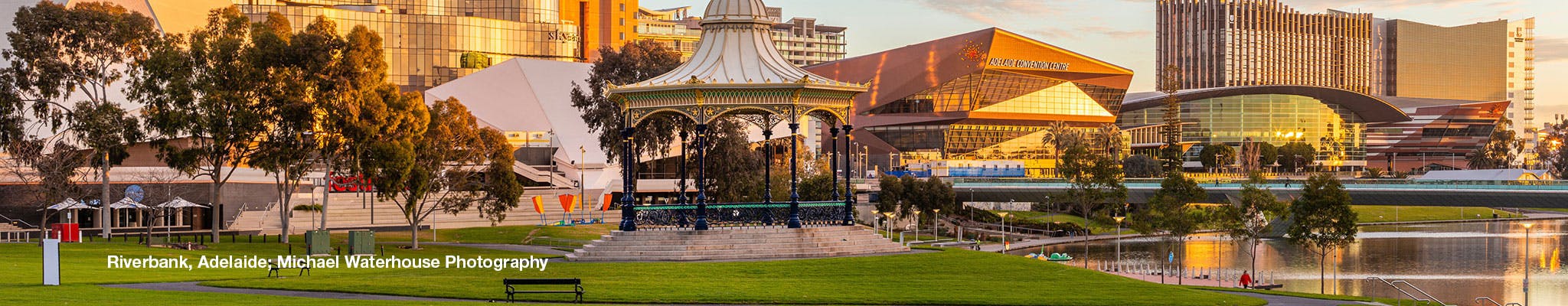
Torrens Riverbank
Why is this area being rezoned?
This area of the park lands will be retained in the Adelaide Park Lands Zone but will have a new subzone applied to better accommodate development that activates the central area of the Torrens riverbank while maintaining the unique park lands setting.
The current Adelaide Park Lands Zone policy anticipates only limited types of development, and the proposed Code Amendment enables more options for future use of the land in this location, such as small-scale shops and community, cultural or tourism-related land uses.
The current Adelaide Park Lands Management Strategy identifies the need to support the activation of the park lands by upgrading and enhancing existing buildings and structures responsive to their park setting.
The strategy also seeks to create a network of activity hubs, create places and attractions that set the park lands apart and promote the park lands as a visitor and tourist destination.
How is the area currently being used?
The area currently accommodates the Torrens Weir and associated restaurants, Par 2 – North Adelaide Golf Course, Tennis SA Clay Courts and Pavilion, Pinky Flat, Jolleys Boathouse, Torrens Rowing Club, Former Water Police Station, King William Road bridge, Elder Park / Rotunda, River Torrens Footbridge and Montefiore Road bridge. The site also includes the Torrens Lake and portion of the River Torrens.
What will happen to Elder Park? Will it be retained as an open public event space?
Elder Park includes the state heritage listed rotunda and is located directly adjacent the state heritage listed King William Road bridge and Festival Centre. The local heritage listed memorial to J.A.H Gardener is also located in Elder Park along the King William Road frontage.
The Code Amendment will not alter either the state / local heritage listings and/or protections over this area and proposes policy which seeks to maintain Elder Park as an open public event space.
What will be the benefits of rezoning this area?
The Code Amendment provides an opportunity to activate the central riverbank area of the Torrens by providing additional low-scale capacity for both on-water and off-water development complementary to existing development, sensitive to the park lands setting, respectful of the heritage values of the area and its open landscaped character. This could include small scale shops and community, cultural or tourism-related land uses.
General
Will the Code Amendment impact on park lands?
Some targeted rezoning of park lands is proposed by the Code Amendment such as in relation to the new Women’s and Children’s Hospital, proposed entertainment-related land uses north of the railway line and the existing Adelaide Botanic High School.
However the land will be retained in the park lands under the Adelaide Park Lands Act 2005. This means that a proposal to change the land use may require a separate process, as outlined under the Act.
The Code Amendment will not alter or impact on the legislative functions of the Adelaide Park Lands Act 2005 and the role of the Adelaide City Council.
The Adelaide Park Lands Authority (and other key organisations with a key interest in the park lands) will be consulted on the Code Amendment and will have the opportunity to provide comment.
Will trees need to be removed?
This proposed Code Amendment does not propose to alter the existing policies relating to the conservation and protection of significant and regulated trees.
The Regulated and Significant Trees Overlay contained in the Code will continue to apply to the affected area.
What will happen to heritage items in the affected area?
The area affected by the proposed rezoning includes a number of heritage listed properties.
The Code Amendment does not propose to alter the listing of these properties.
What is the Environment Protection and Biodiversity Conservation Act 1999, and why is it relevant?
The Environment Protection and Biodiversity Conservation Act 1999 (EPBC Act) is the Australian Government’s central piece of environmental legislation. The EPBC Act ensures a consistent approach to protect matters of national significance, including national heritage places.
Any action that is likely to have a significant impact on matters of national environmental significance needs to be assessed under the EPBC Act.
In this context, the rezoning does not trigger the need for assessment under the EPBC Act. However, the EPBC Act will need to be considered during the detailed design and decision-making stage of any public infrastructure projects which are consequential to this Code Amendment process.
Who has been consulted on the draft Code Amendment?
Land in the area affected by this proposed Code Amendment is held by both private and public entities. These include the City of Adelaide, Minister for Infrastructure and Transport, Minister for the Arts, Urban Renewal Authority, University of Adelaide and University of South Australia, to name a few. In addition to these stakeholders, the broader Riverbank Precinct also contains various occupiers and leaseholders who contribute to the vibrancy of the precinct.
In this context, all land owners, occupiers, leaseholders and other relevant stakeholders in the affected area have been directly notified regarding the release of the Riverbank Precinct Code Amendment for public consultation. Traditional Owners of the land within the affected area have also been notified.
Further detail on the engagement undertaken is set out in the Engagement Plan available at plan.sa.gov.au/en/codeamendments.
What engagement is planned with Traditional Owners?
The Code Amendment recognises the strong spiritual connection of Traditional Owners to the River Torrens and its environs. Traditional Owner groups have been directly notified and invited to participate in the Code Amendment engagement process.
When will I have a chance to have my say?
The Code Amendment is open for consultation from 15 September to 27 October 2021.
More information about how you can have your say, including an online feedback form, is on the PlanSA website.
Does this allow 20 storey buildings to be built along the Torrens?
No. Buildings of up to 20 storeys are already allowed under the Planning and Design Code in the Entertainment subzone. The Code Amendment proposes to extend this subzone to the north of the railway line, west of Montefiore Road.
However, buildings of that size would be situated closer to North Terrace where there are existing buildings of similar height, and would not be allowed adjacent to the River Torrens.
Developments closer to the River itself would need to transition down in height to be of a scale lower than what would be allowed near North Terrace.
Would commercial development of up to 15 storeys be allowed near the new Women’s and Children’s Hospital (WCH)?
No. General commercial buildings are not supported within the Health Subzone proposed to apply to the new WCH.
And while building heights of up to 15 storeys are allowed, this would be limited to health, education and research facilities.
Development would also be scaled, with taller buildings fronting North Terrace and lower buildings located closer to the parklands in a manner that complements the heritage features of existing buildings, such as the Police Barracks and Old Adelaide Gaol. These sites are also protected through specific heritage policies.
Is development in the Riverbank’s Active Waterfront Precinct uncapped?
No. The Riverbank Subzone is within the Adelaide Park Lands Zone. The subzone is applying to the southern and northern sides of the River Torrens and only allows ‘low rise’ small-scale development of up to two storeys and development up to 200 square metres floor space. Existing examples of similar developments include Jolley’s Boathouse, the River Café and rowing clubs. All such developments would require relevant council leases and development approvals.
What sort of development would be allowed directly along the Torrens?
The current Adelaide Park Lands Zone that applies to Pinky Flat allows for a number of different types of land use, including conservation work, outbuilding associated with open space maintenance, recreation area, shop, sporting field or club facility and structures associated with a public facility such as bike and vehicle parking, picnic/barbeque area, shelter and toilets.
These policies would be retained, while the proposed amendment opens up opportunities for low rise developments (i.e. up to two storeys) that are community, tourism, shop or licensed premises, consistent with what is currently allowed on the southern bank of the River.
Any proposal would need to be assessed in line with the Aboriginal Heritage Act 1988, which provides protection of Aboriginal sites, objects or remains. There are also specific policies in the Adelaide Park Lands Zone about the protection of cultural sites of significance.
Would the public be notified of any development at the Old Adelaide Gaol or Police Barracks?
The proposed Code Amendment would make the notification process the same as other City zones across Adelaide.
Public notification would be required where the proposed development involves the demolition or alteration of a State or Local Heritage Place, such as the Old Adelaide Gaol or Police Barracks.
Will this lock up 70 hectares of land and remove it from public use?
No. The Code Amendment seeks to retain significant areas of the northern and southern banks of the River Torrens in the Adelaide Park Lands Zone through the application of a new Riverbank Subzone. This would provide additional scope for land uses to activate these areas for public use.
It seeks to encourage greater public access and activation of green spaces, through the provision of cycling and pedestrian pathways in areas that are currently either inaccessible or underutilised.
