

FAQs
Proposed key terms
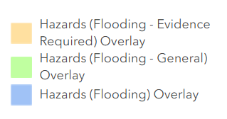
- the Hazards (Flooding) Overlay, which applies to areas that can be subject to an intolerable flood risk, where development should generally be avoided
- the Hazards (Flooding – General) Overlay, which applies to areas with tolerable flood risk and seeks actions such as raising floor levels to mitigate flood risk
- the Hazards (Flooding – Evidence Required) Overlay, which applies to areas where there is no suitable flood study data so precautionary actions are required, such as ensuring the floor levels of new homes are raised above the kerb.
What does flood risk mean?
Flood risk is the potential risk of flooding to people, their social setting (i.e. socioeconomics, household composition, access to housing or transportation) and their built and natural environment(1).
It is a combination of the chance of a flood occurring and the consequences for people, property and infrastructure. The consequences depend on the community’s exposure and vulnerability to the flood impacts.
The level of risk depends on how likely a flood event is to occur and the impact that the flood event would have on the community.
(1) As defined by The Australian Institute for Disaster Resilience Handbook 7: Managing the Floodplain: A Guide to Best Practice in Flood Risk Management in Australia (AIDR 2017)
What is considered tolerable and intolerable flood risk?
In relation to a flood hazard overlay, flood risk varies from tolerable flood risk, where actions can be taken to mitigate the impacts of flooding, to intolerable flood risk where actions would be required to avoid or reduce the risk.
What does flood hazard mean?
Flood hazard means the potential loss of life, injury and economic loss caused by future flood events.(1)
The level of flood hazard relates to how severe the flood event may be. This can be affected by flood depth, velocity and extent, as well as factors like topography.
(1) As defined by AIDR 2017
What is the difference between flood hazard and flood risk?
A flood hazard exists whether or not it poses a risk of impacting people.
Flood hazard is based on flood behaviour, such as flood depth or velocity, and flood risk considers what would be lost or damaged, such as a home or hospital.
The image below provides an example showing the same flood hazard but the risk changes depending on the land use exposed to the hazard.
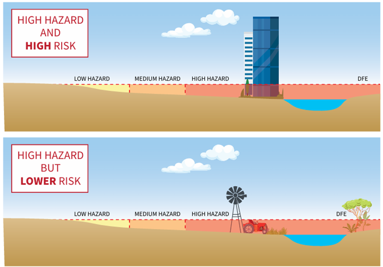
Figure: Difference between flood hazard and risk from Queensland Reconstruction Authority, Planning for Stronger, More Resilient Floodplains dated 2012
What is Annual Exceedance Probability (AEP)?
Annual Exceedance Probability (AEP) is a term used to the express the likelihood of a flood of a given size or larger occurring in a given year.
For example, a 1% AEP means that there is a 1% chance in any given year of this kind of flood event occurring. This is often referred to as a 1 in 100-year flood event.
How are floods classified and what are flood classification curves?
Flood hazard classification curves are used to determine the level of safety and damage that floodwaters of a particular depth and velocity would have on a community.
Australian Disaster Resilience Guideline 7-3: Flood Hazard (AIDR 2017) identifies thresholds for each hazard classification level, increasing from H1 to H6 as follows:
| Hazard classification | Vulnerability |
| H1 | Generally safe for vehicles, people and buildings |
| H2 | Unsafe for small vehicles |
| H3 | Unsafe for vehicles, children and the elderly |
| H4 | Unsafe for vehicles and people |
| H5 | Unsafe for vehicles and people, all building types vulnerable to structural damage, some less robust building types vulnerable to failure |
| H6 | Unsafe for vehicles and people, all building types considered vulnerable to failure |
The curves are particularly useful to determine the level of vulnerability in circumstances such as where the flood depth is low but velocity is high, resulting in a higher flood hazard and vulnerability.
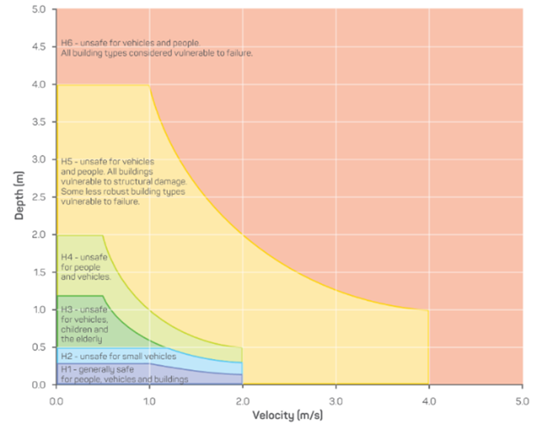
Figure: Australian Disaster Resilience Guideline 7-3 Flood Hazard published by the Australian Institute for Disaster Resilience dated 2017 and referred to the Flood Hazard, Technical Report 2014/07, prepared by Smith GP, Davey EK and Cox RJ at the Water Research Laboratory, University of New South Wales, Sydney dated 2014.
What are flood hazard overlays?
The Planning and Design Code contains three ‘overlays’ that set out planning rules to guide development in areas with a flooding hazard:
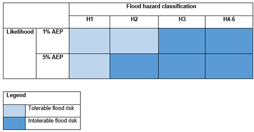
How are the flood hazard classification curves used in updating the flood hazard overlays in the State-Wide Flood Hazard Code Amendment?
The flood hazard classification curves have played an important role in identifying where the level of flood risk is considered tolerable and where it is considered intolerable.
The 30 new and enhanced flood studies, commissioned by the department to inform the updated mapping and related policies, used flood hazard classification curves to identify the level of flood hazard and vulnerability for an area.
The likelihood of a one in 100-year flood (1% AEP) and one in 20-year flood (5% AEP) to 2050 and the consequence (flood hazard classification levels with vulnerabilities in H1-H6) were put into a matrix to identify potential areas with tolerable or intolerable risk.
This approach was used to inform the new and updated mapping of the Hazards (Flooding – General) Overlay and Hazard (Flooding) Overlay respectively, with the associated policies.
The Hazards (Flooding – General) Overlay has been applied to areas with tolerable flood risk, where actions can be taken to mitigate the risk.
The Hazard (Flooding) Overlay has been applied to areas where there could be an intolerable flood risk and where actions would be required to avoid or reduce the risk.
About the planning rules
- the Hazards (Flooding) Overlay, which applies to areas that can be subject to an intolerable flood risk, where development should generally be avoided
- the Hazards (Flooding – General) Overlay, which applies to areas with tolerable flood risk and seeks actions such as raising floor levels to mitigate flood risk
- Hazards (Flooding – Evidence Required) Overlay, which applies to areas where there is no suitable flood study data so precautionary actions are required, such as ensuring the floor levels of new homes are raised above the kerb.
How are the flood hazard mapping and planning rules included in the Planning and Design Code?
The Planning and Design Code contains three ‘overlays’ that set out planning rules to guide new development in areas with flooding hazard:
The draft State-Wide Flood Hazard Code Amendment proposes to update these overlays, focussing on updating mapping and making this more consistent across catchments, improved planning rules for development in the areas of the three overlays and a process for efficient future overlay mapping updates.
What kind of flooding does the draft State-Wide Flood Hazard Code Amendment address?
Proposed updates to mapping and planning rules in the flood hazard overlays address flooding along water courses, such as creeks and rivers (riverine flooding) and surface water (pluvial flooding).
Proposed changes to the planning rules
- avoid development where subject to an intolerable flood risk
- account for future flood hazard to 2050
- account for extreme events for key infrastructure, emergency services facilities, community facilities and buildings related to vulnerable communities such as schools and aged care facilities
- use more consistent terminology.
- mitigate flood hazard where subject to a tolerable risk
- account for future hazard to 2050
- account for extreme events for buildings for vulnerable communities, community facilities, key infrastructure and emergency services facilities
- use more consistent terminology
- remove Technical Numeric Variations (TNVs) that are outdated in light of the new and enhanced flood studies and mapping.
- there is an overriding need for the planning use
- there is no alternative site outside of the overlay that would address the identified need
- the development enables the uninterrupted operation of services and reduces the likelihood of entrapment during an extreme flood event.
What are the proposed changes to the Hazards (Flooding) Overlay?
The Hazards (Flooding) Overlay applies to areas that can be subject to an intolerable flood risk. Proposed updates to the mapping are based on new and enhanced flood studies and mapping products. Typically, this Overlay applies to creek and riverbeds and channels and areas that rivers and creeks that are known to break during significant storm events. The associated planning rules seek to:
What are the proposed changes to the Hazards (Flooding – General) Overlay?
The Hazards (Flooding – General) Overlay applies to areas with tolerable flood risk and seeks actions such as raising floor levels of new buildings to mitigate flood risk. Proposed updates to the mapping are based on new and enhanced flood studies and mapping products.
The associated planning rules seek to:
What are the proposed changes to the planning rules for the Hazards (Flooding – Evidence Required) Overlay?
The Hazards (Flooding – Evidence Required) Overlay applies to areas where there is no suitable flood study data and precautionary actions are consequently appropriate, such as ensuring the floor level of homes are raised above the kerb.
The Hazards (Flooding – Evidence Required) Overlay mapping is proposed be significantly reduced using new flood studies or coarse-scale data, and retained in certain zones and areas with insufficient flood data to rule out the potential for flood risk.
No changes are proposed to the planning rules in this overlay.
How do the proposed changes help protect facilities for our most vulnerable community members and infrastructure for critical services from the impacts of floods?
The draft State-Wide Flood Hazard Code Amendment includes new and updated planning rules to provide greater consistency and protection to buildings for vulnerable communities, such as schools, hospitals and aged care facilities, from extreme flood events (0.2% AEP or the 1 in 500-year flood event in a 2050 scenario).
It also provides greater consistency and protection to community and emergency services facilities and infrastructure for critical services, such as the supply of electricity.
The draft State-Wide Flood Hazard Code Amendment includes introducing a new land use definition for ‘buildings for vulnerable communities’ to provide greater consistency and clarity in assessing these land uses against the planning rules in the flood hazard overlays.
It also strengthens planning rules so that buildings for vulnerable communities, community facilities, key infrastructure and emergency services facilities are not located in the Hazards (Flooding) Overlay, unless:
These proposed changes means that the design and operation of these buildings during an extreme flood event are to be taken into account, as well as where they are located.
Questions for landowners
- many insurers include flood cover as a compulsory part of taking out a household policy
- some insurers include flood as a standard inclusion but allow the policy holder to remove it – this is known as opt-out flood cover
- some insurers will cover flood in policies only up to very low defined values – for instance, damage of $15,000 or less
- some insurers will not cover flood under any circumstances.
What are the benefits and impacts of these proposed changes for homeowners?
The draft State-Wide Flood Hazard Code Amendment proposes to update flood hazard overlay mapping using new and enhanced flood studies and coarse-scale data based on river and surface water flood information to better reflect flood hazard for new development.
More accurate overlay mapping means that new developments, such as building new homes or extensions/additions to existing homes, are located and designed to minimise potential flood exposure to property damage or people.
Currently, precautionary planning rules are in place across large areas of the state where there is no suitable flood study data, such as requiring the floor level of homes to be raised above the kerb.
An important benefit of the proposed overlay mapping updates is that the area where these precautionary actions are required is to be significantly reduced.
Overall, there are more than 280,000 properties where these precautionary measures are no longer considered necessary, due to the more accurate overlay mapping.
Where these precautionary rules are no longer considered necessary, people will no longer need to raise their house levels or provide a flood study to rule out flood risk when applying for new development.
This will reduce planning rules, increase design opportunities, and cut costs involved in raising the floor level.
How do I know which overlays would apply to my property under the proposed draft State-Wide Flood Hazard Code Amendment and whether they would change?
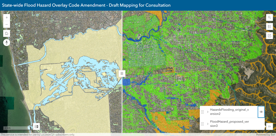
You can view the draft flood hazard mapping(External link)(External link) online and zoom into the map or search for an address to see which overlays apply to your allotment.
You can then move the slider across the screen to compare the existing flood hazard overlays (left side of the screen) with the proposed updated flood hazard overlays (right side of the screen) to see if there is a change proposed to your property.
How might the draft State-Wide Flood Hazard Code Amendment impact building insurance?
Flood insurance is often built into insurance policies, including home and contents, strata title, motor vehicle and business insurance policies.
The risk of a flood occurring is reflected in the cost of the premium – property owners with a high risk of flood will pay a higher premium than other property owners.
Insurers treat floods in different ways in their policies:
It’s important to know that the insurance industry uses a range of flood maps and studies from local, state, Commonwealth and private sources to set insurance premiums for properties. The insurance industry currently uses maps that show the present-day river-related flood hazard for properties to determine flood risk.
The draft State-Wide Flood Hazard Code Amendment seeks to minimise the potential impacts for river-related and surface water flood impacts in areas identified as having an intolerable flood risk, generally by retaining areas free from development.
In areas with a tolerable flood risk, the draft State-Wide Flood Hazard Code Amendment seeks actions such as raising floor levels to minimise any impacts.
Further, the draft State-Wide Flood Hazard Code Amendment proposes approximately 280,000 properties be removed from a flood hazard overlay, due to enhanced flood hazard mapping.
When released, this flood data can be used by authorities to plan and build flood mitigation works, which in turn could assist with flood hazard mitigation and insurance costs.
In short, insurers use a variety of sources and flood maps to set insurance premiums for properties. The updated flood hazard mapping is proposed to provide greater certainty in the assessment of development.
For more information refer to:
What council areas would have the greatest changes in flood hazard mapping?
Council areas experiencing the greatest changes in flood hazard mapping are generally those areas where new detailed flood studies have been undertaken, such as the City of Adelaide, Copper Coast Council, and City of Port Lincoln.
The draft State-Wide Flood Hazard Code Amendment proposes to remove the Hazard (Flooding – Evidence Required) Overlay from large areas of the state, reducing the requirements for new development in these areas.
You can compare the existing flood hazard mapping against the proposed flood hazard mapping online using the Map Viewer tool.
Mapping
- updating the area of a flood hazard overlay to reflect flood information in a stormwater management plan that has been consulted on and approved by the Stormwater Management Authority
- reducing the area of a flood hazard overlay to reflect flood information obtained through a legislated process, such as flood investigations that have informed a development application approved under the Planning, Development and Infrastructure Act, 2016.
Why does the mapping look different in my area compared to the surrounding areas?
The updated flood hazard overlays have been informed by a range of mapping data from different sources.
The most contemporary hazard mapping comes from the 30 new and enhanced flood studies procured by the department in 2022. Other areas may have updated mapping from previous council flood studies.
In less built-up areas or areas without sufficient flood data to rule out the potential for flood risk, coarse-scale data based on flooding of watercourses such as creeks and rivers, and surface water information, informed mapping updates.
For example, the parcel-based mapping from the Unley Urban Floodplain Mapping 2019 council data would look different the refined mapping in Marion which used the commissioned 2022 Sturt River (Lower) flood study.
These different data sources mean the flood hazard overlays may look different but still represent the best available data for use today.
The draft State-Wide Flood Hazard Code Amendment also proposes to enable a streamlined way to update flood hazard overlays in the future, as more up-to-date flood studies become available.
How do the proposed changes help ensure the flood hazard mapping can be updated more easily and regularly?
The draft State-Wide Flood Hazard Code Amendment proposes to enable the Minister for Planning to update the flood hazard overlays as new flood studies become available without the need for a full Code Amendment process of initiation, investigations, consultation and engagement reporting.
This would allow more timely and efficient updates to better reflect flood hazard, relating to development assessments across the state.
Because the proposed process for the Minister to update the overlays does not involve community engagement, it is intended that this process be limited to:
It is intended that the State Planning Commission will prepare a practice direction to outline standard requirements for the flood studies and information, so they can be incorporated into the flood hazard overlays consistently.
The practice direction is proposed to complement the upcoming flood study guidelines for South Australia (being developed by Department for Environment and Water) to specify requirements, including flood study circumstances, minimum parameters, documentation and submission method.
What is coarse scale data?
Coarse-scale flood data is generalized, low-resolution flood modelling used for regional planning, broad-level risk screening, and emergency management.
It covers large areas quickly and inexpensively but does not provide fine-grained information gained through detailed flood studies.
Projected climate conditions
How is climate change projected to impact the frequency of flood events in South Australia?
While climate trends projected to 2050 and beyond indicate that rainfall will decline, more intense rainfall events are expected, resulting in more frequent flooding events.
For more information about how projected climate conditions are affecting South Australia, visit the Department for Environment and Water’s website.
How does the draft State-Wide Flood Hazard Code Amendment help mitigate the impacts of projected climate conditions?
The draft State-Wide Flood Hazard Code Amendment aims to protect people, property and the environment from the impact of flood events, now and in the future, by avoiding development in intolerable flood-risk areas and ensuring suitable building designs in tolerable flood-risk areas.
New, detailed flood studies have been undertaken to update and enhance flood hazard mapping across the state as part of this draft State-Wide Flood Hazard Code Amendment. The flood studies cover a range of flood events (including modelling of a 2050 scenario with projected climate conditions and development growth).
Updating the flood hazard mapping and policies using modelling to 2050 supports climate resilient development and design and reducing projected climate risks to infrastructure.
This delivers on the action to ‘Integrate future climate change risk into hazard mapping and information’ outlined in the South Australian Government Climate Change Resilience and Adaption Actions.
The draft State-Wide Flood Hazard Code Amendment also reviews the process for updating flood mapping in the Planning and Design Code to ensure it can be updated regularly and consistently to reflect contemporary flood studies and data as they are undertaken and produced.
In the context of the current urgent need for more homes to be built in South Australia, the draft State-Wide Flood Hazard Code Amendment will help identify areas where development should be avoided due to intolerable flood risk, and where there is tolerable flood risk and new homes can be built safely with mitigation measures in place to minimise flood risk, now and in the future.
Why is the new and enhanced flood hazard mapping based on modelling for the year 2050?
Regional plans set the direction for future planning and development for each planning region across South Australia.
Recent updates to the state’s regional plans, including development and population projections, plan for a growing South Australia to the year 2050.
Flood hazard modelling to the year 2050 has been used as a basis for the new and enhanced flood studies and mapping to account for future hazard and align this projection with the regional plans.
Flood Hazard Mapping and Assessment Project and flood studies
- reduced the extent of the Hazards (Flooding - Evidence Required) Overlay for 13 local government and several outback areas, based on more recent flood studies and previously unavailable flood hazard mapping
- applied the Hazards (Flooding – Evidence Required) Overlay to the north-eastern portion of the Port Adelaide Enfield council area, as a precautionary measure, until updated flood hazard mapping could be prepared and implemented into the Planning and Design Code.
- Fleurieu Peninsula Townships
- Onkaparinga River Lower
- River Torrens (Lower) and River Torrens (Upper) Townships
- Sturt River (Lower)
- Clare Gilbert Valleys
- Light River
- Naracoorte
- Smith Creek
- Gawler extended Model
- Adams Creek and Greater Edinburgh Park, Little Para River
- First to Fifth Creek
- Marion Holdfast Bay
- Nuriootpa
- Port Lincoln
- West Lakes
- Goolwa to Port Elliot
- Balaklava to Wakefield
- Barker Inlet
- Bremer River at Langhorne Creek
- Cobbler Creek
- Lefevre Peninsula
- Moonta Area
- Mount Barker
- Port River East
- Port Road
- Strathalbyn
- Upper Onkaparinga River Townships
- Victor Harbor
- Wallaroo
- Kadina.
- Burnside Floodplain Mapping 2019 (First to Third Creeks Catchment)
- Auburn Stormwater Management Plan 2019
- Brown Hill Creek Urban Catchment Stormwater Management Plan (2017)
- Dry Creek Stormwater Management Plan 2021 (noted this was draft at stage 1 and completed by stage 2).
- Anderson Avenue
- Barker Inlet Central Stormwater Management Plan 2021
- Dry Creek Stormwater Management Plan 2021
- Combined Longterm Litle Para Helps Road, Adams Creek 2011
- Naracoorte Hazard 2018
- Old Dry Creek 2008
- Sturt Creek Urban Catchment 2017
- Torrens Road Drainage Authority 2015
- Unley Urban Floodplain Mapping 2019.
- Rainfall intensity: ARR 2019 predicted an increase in rainfall (intensity and depth) of 5% per °C of local warming.
- Sea-level rise: the Coast Protection Board recommended a sea-level rise of 300 mm – sea-level rise is relevant for watercourses or stormwater infrastructure that flows out to sea.
- Future development:
- Planning policy considerations such as zoning, site area and frontage were used to identify potential for infill development. The likely timeline of infill development was guided by the value of the home and other improvements relative to the land value. A lower ratio generally indicates that the site is a more likely candidate for redevelopment in the short to medium term.
- For greenfield development it was assumed that land with a land division application proposing lots will be developed. Remaining land was estimated to be developed over time using the following assumptions:
- privately owned land will be developed at 50% of full potential (allowing for owners that hold onto their land or don’t develop to full potential)
- company owned land will be developed at its full potential
- other greenfield land (community/government) will not be developed.
What is the State Planning Commission’s Flood Hazard Mapping and Assessment Project?
The State Planning Commission, together with the Department for Housing and Urban Development, is undertaking the Flood Hazard Mapping and Assessment Project to highlight the risk of potential flood hazards, while delivering more consistent and contemporary mapping of riverine and surface water flood hazards for the state.
It also aims to help mitigate the impacts of projected climate conditions such as more frequent, extreme weather events and sea level rise.
The project aims to provide greater certainty when undertaking and assessing new developments and also in informing rezoning, regional planning and emergency management. In addition, the data will serve as a valuable asset across several government departments, services and activities.
The first stage involved delivering the Flooding Hazards Mapping Update Code Amendment, which updated the Hazards (Flooding - Evidence Required) Overlay for 13 local government areas and several townships in outback areas of the state.
The second stage involved procuring new, detailed flood studies to update and enhance flood hazard mapping across the state. The flood studies cover a range of flood events (including modelling of a 2050 scenario with projected climate conditions and development growth scenarios).
The new and enhanced flood hazard mapping used improved data and more consistent modelling to better identify flood hazard. The updated data and mapping informed the proposed changes to flood policies and mapping in the draft State-Wide Flood Hazard Code Amendment.
The State-Wide Flood Hazard Code Amendment is the final stage of this project.
The project is funded by a $3 million COVID-19 stimulus grant. Visit the PlanSA website to learn more.
Where can I find out more about the Flooding Hazards Mapping Update Code Amendment?
The Flooding Hazards Mapping Update Code Amendment updated the extent of the Hazard (Flooding – Evidence Required) Overlay in the Planning and Design Code in 13 local government areas and several outback areas of the state.
The code amendment was finalised in 2021 and:
This code amendment was the first stage of the Flood Hazard Mapping and Assessment Project.
Further information about the Flood Hazards Mapping Update Code Amendment is available on the PlanSA website.
What detailed flood studies were commissioned as part of stage 2 of the Flood Hazard Mapping and Assessment Project?
During stage 2 of the project, the department commissioned 30 new and enhanced flood studies for areas subject to higher flood risk, impacting development assessment, infrastructure delivery and emergency services management.
These studies, carried out in 2022, included:
The mapping resulting from these studies is demonstrated in the draft flood hazard overlays released for consultation as part of the State-wide Flood Hazard Code Amendment.
These new and enhanced flood studies will also be used by other South Australian government agencies for other purposes. For example, the Department for Environment and Water will incorporate these studies in updating their Flood Awareness Map, and South Australian State Emergency Service (SES) will use these studies to help guide emergency management planning.
The detailed studies are also available to view on the PlanSA website as part of the consultation process.
What regional coarse-scale data was commissioned as part of stage 2 of the Flood Hazard Mapping and Assessment Project?
During stage 2 of the project, the department purchased regional coarse-scale riverine and surface water data, where no detailed flood study was available to map flood hazard.
Coarse-scale flood data is generalized, low-resolution flood modelling used for regional planning, broad-level risk screening, and emergency management. It covers large areas quickly and inexpensively but does not provide fine-grained information gained through detailed flood studies.
The data was purchased at a 5 metre scale for a 1 in 100-year flood for greater Adelaide and 30 metre scale for a 1 in 200-year flood for far north, regional and remote areas.
Given the scale and accuracy is much broader than for a detailed flood study, the coarse data was used to identify areas that may require a detailed flood study and areas where a detailed flood study was not required.
The flood data covered a 5 metre buffer on each side of watercourses in urban areas and 15 metres each side of watercourses for regional areas. It also covered surface water exceeding 1 metre in depth over an area of 5 metres for urban areas and 30 metres for regional areas. This data was overlapped with flood studies where a clear flood study extent was not available.
This modelling was used to inform the Hazards (Flooding – Evidence Required) Overlay and enabled the extent of this overlay to be significantly reduced.
Were any other flood studies released during the Flood Hazard Mapping and Assessment Project?
Additional council flood studies and flood hazard information were made available during the project.
These included flood studies that could not be released when the Planning and Design Code commenced and flood studies used to reduce the Hazards (Flooding – Evidence Required) Overlay in the Flooding Hazards Mapping Update Code Amendment (stage 1).
Council flood studies made available under stage 1 of the project were:
Council flood studies and flood hazard data made available under stage 2 of the project included:
These flood studies are proposed to be used in the new and enhanced Hazards (Flooding) Overlay and Hazards (Flooding – General) Overlay mapping as part of the State-wide Flood Hazard Code Amendment.
The council has prepared more recent flood studies. Will these studies be included in the draft State-Wide Flood Hazard Code Amendment mapping?
No, only the flood studies made available through the Flood Hazard Mapping and Assessment Project and consulted on as part of the draft State-Wide Flood Hazard Code Amendment would be used.
However, the draft code amendment proposes a way to make it faster and easier to update flood hazard mapping as more contemporary studies become available.
What method was used for undertaking new and enhanced flood studies and preparing new flood hazard mapping?
During stage 2 of the project, 30 new and enhanced flood studies were commissioned to update the spatial application of the Hazards (Flooding) Overlay and Hazards (Flooding – General) Overlays.
The studies used contemporary hydrological information, consistent methodology, updated Light Detection and Ranging (LiDAR) Digital Elevation Modelling (DEM), and flood modelling to 2022 using current average data, and flood modelling to 2050 with the following projected climate conditions and development assumptions:
The studies quantified flood hazard using the flood hazard classification curves and produced flood hazard mapping for three flood events to better understand flood hazard and align with national guidance[1]. These flood events included 5% AEP (1 in 20-year), 1 in 100-year (1% AEP) and 1 in 500-year (0.2% AEP) flood events for a 2022 scenario and a 2050 scenario.
Maps showing flood depth, velocity, and data for water surface elevation were also prepared to supplement the flood hazard modelling.
The modelling was then used to inform the Hazards (Flooding) Overlay and Hazards (Flooding – General) Overlay mapping.
--------------------
[1] Australian Disaster Resilience Guideline 7-3 Flood Hazard published by the Australian Institute for Disaster Resilience dated 2017
Other flooding work
A stormwater management plan was released for consultation in my area recently. How and why is this different from the draft State-Wide Flood Hazard Code Amendment?
Stormwater management plans are broad, long-term plans that guide how stormwater is managed across a council or multiple council areas to minimise flood risk and enhance water quality. These plans can be used by councils to identify infrastructure works to address these issues.
The Planning and Design Code sets out rules used to avoid, minimise and mitigate flood hazard impact on new property development, for example, needing to raise the floor level of a home above the flood level to mitigate against potential flood risks.
Draft updates to the flood hazard mapping and planning rules within the code proposed by the draft State-Wide Flood Hazard Code Amendment use data and methods that address potential flood risk related to property development across South Australia.
Therefore, the flood hazard mapping in a stormwater management plan and the draft State-Wide Flood Hazard Code Amendment may look different for the same area, as each serve a different purpose and may use different data or methods to determine flood risks for their specific use. The Code Amendment’s proposal to enable updates the area of a flood hazard overlay to reflect flood information in a stormwater management plan may over time result in enhanced alignment between flood overlay mapping in the Planning and Design Code and approved stormwater management plans.
There are other flood related projects currently underway – what are they and how do they relate to the draft State-wide Flood Hazard Code Amendment?
There are several complementary projects underway in parallel to the draft State-Wide Flood Hazard Code Amendment, which are led by the Department for Environment and Water and the Department for Housing and Urban Development.
Flood Awareness Map
The Department for Environment and Water is developing a new and improved online resource to collect, manage and provide flood risk information to South Australians. Public consultation was undertaken to understand community needs and preferences in accessing flood risk information to help guide the online resource in late-2024. The Flood Awareness Map is expected to be published mid-2026.
Flood study guidelines for South Australia
Department for Environment and Water is developing flood study guidelines for South Australia, in response to national guidelines, to enable more consistent flood studies being prepared across the state for future projects, including the potential for future mapping updates in the Planning and Design Code. These guidelines are expected to be published in mid-2026.
Flood development guidelines
The Department for Housing and Urban Development is preparing flood development guidelines, providing guidance on developing in floodplain areas in a way that keeps people and property safe. South Australian Fire and Emergency Services Commission (SAFECOM) funding has been secured to deliver the guidelines, which will complement the final code amendment. These guidelines are expected to be published in late-2026.
What is the difference between the flood hazard mapping in the Planning and Design Code and Department for Environment and Water’s Flood Awareness Map?
Flood hazard mapping in the Planning and Design Code is used by planners to assess development against the flood hazard overlays to avoid, minimise, and mitigate the impact of flooding on new development.
Policies in the overlays consider whether the potential flood risk is intolerable and development should be avoided, or areas where there is a tolerable level of flood risk which can be mitigated through location and development design.
The Department for Environment and Water’s Flood Awareness Map allows the public to learn about flood risk for a property or an area using flood study maps commissioned by local and state government for a variety of purposes. This detailed mapping is also used by emergency services and flood management organisations to develop flood management plans and for emergency planning and response relating to flood events.
In short, the flood hazard mapping in the Planning and Design Code is specifically used to assess development, whereas the Flood Awareness Map is used for emergency planning and response, as well as a general tool to learn about potential flood hazard in an area.
How does the draft State-Wide Flood Hazard Code Amendment relate to the State Emergency Management Plan?
Delivering a state-wide update of the flood hazard overlays in the Planning and Design Code is one of the short-term priorities for flood management in South Australia, outlined in the State Emergency Management Plan: Flood Hazard Risk Reduction Plan 2024.
It aims to protect people and property from the impacts of floods through generally avoiding development in areas of intolerable flood risk and enabling development with measures in place to mitigate tolerable flood risk. It also aims to remove unnecessary restrictions on building in areas where flood mitigation is not necessary.
Do the draft State-Wide Flood Hazards Code Amendment planning rules impact development along the River Murray?
No, there are separate planning rules that support flood-resilient development along the River Murray, which were updated in 2024.
The River Murray Flood Resilience Code Amendment was undertaken to assist the rebuilding process following the 2022-23 flood and mitigate the impacts of future River Murray flood events.
These amendments were informed by the extent and levels of floodwaters during the 2022-2023 flood and aim to minimise the impact of future River Murray floods on permanent residents, shack owners and tourist parks.
Do the State-wide Flood Hazards Code Amendment planning rules address coastal flooding?
No, the Coastal Areas Overlay outlines specific planning rules that address development in coastal areas and where the rules apply.
It includes rules to minimise coastal flood risk on development, including due to tidal water and sea level rise, as well as rules to protect the coastal environment from impacts due to development.
Examples of planning rules to minimise coastal flood impacts include requiring minimum floor heights above the standard level of sea flood risk and 1 metre of sea level rise, and ensuring buildings are set back far enough to allow for coastal retreat.
