
FAQs
- apply the Master Planned Neighbourhood Zone, new Emerging Main Street Subzone, and concept plans for land use and basic infrastructure to the Affected Area, to guide housing and community development that is aligned with infrastructure supply
- create and apply a new Overlay (the Coordinated Development Overlay) over the Affected Area to defer urban development until the air quality monitoring is completed and infrastructure commitments are secured to support housing growth
- apply the Affordable Housing Overlay and the Urban Tree Canopy Overlay over all of the Affected Area of land
- remove the existing Minimum Site Area (16 hectares) Technical and Numerical Variations layer from the part of the Affected Area currently zoned Rural.
- introduce a new recommendation that enables the removal of policies established to defer urban development through a future Complying Change to the Code, thereby allowing housing development to proceed once the following conditions are satisfied:
- completion of air quality monitoring and assessment, with findings that support the rezoning of the Affected Area to the designated urban zone
- securing infrastructure commitments through an approved infrastructure delivery scheme and /or formal agreements.
- 4,063 dwellings have been constructed over a five-year period (2017-2021)
- only 1,550 development ready allotments were available as of June 2022
- the estimated future demand for allotments in the region ranges from 2,250 to 4,050
- recent stimulus packages—like the Homebuilder Grant Scheme—have resulted in increased demand for new houses.
- the area presents a logical expansion of the existing urban area with direct linkages to a residential development located directly to the west and north
- the location being well serviced by existing road infrastructure and bus routes
- the location being well serviced by existing social infrastructure and employment – including schools, nearby district centre, emergency services, and community facilities.
- View the Concept Plan for Basic Infrastructure for the Sellicks Beach Growth Area on YourSAy
- Read the infrastructure schemes for growth areas fact sheet on YourSAy
- Find out more about infrastructure schemes at: plan.sa.gov.au/our_planning_system/schemes/infrastructure_schemes
- community facilities
- educational facilities
- health and medical services
- public transport.
- indentifying open spaces and vegetation corridors that provide critical habitat features such as tree hollows and contribute to broader wildlife corridors
- placing infrastructure within areas already cleared or impacted by weed infestations, including paddocks used for agriculture and horticulture.
- Attend one of our community information sessions to ask any questions
- Email your questions to PlanSA.sa.gov.au
- Department for Housing and Urban Development office:
- Level 9, 83 Pirie Street, Adelaide, 9am to 5pm
- Level 9, 83 Pirie Street, Adelaide, 9am to 5pm
- City of Onkaparinga Council offices:
- Aldinga Office and Library 11 Central Way, Aldinga Beach 5173 Monday to Friday: 9:30am to 1pm
- Aldinga Community Centre 7 Stewart Ave, Aldinga Beach 5173 Monday to Friday 8.30am to 4pm
- Willunga Office St Peters Terrace, Willunga 5172 Monday to Friday 9.30am to 5pm
- Noarlunga Office Ramsay Place Noarlunga Centre 5168 Monday to Friday 8.30am to 5pm.
- completing the survey on YourSAy
- sending an email: PlanSASubmissions@sa.gov.au (subject: Submission – Sellicks Beach Growth Area Joint Amendment)
- writing to: Code Amendment Team, GPO Box 1815, Adelaide, SA 5001.
What is being proposed at Sellicks Beach?
The Government of South Australia is proposing to rezone approximately 134 hectares of land in Sellicks Beach to enable a new master-planned community that will deliver up to 1700 new homes, an activity centre as well as open space for the Sellicks Beach community.
The Joint Amendment proposal will facilitate managed housing growth of Sellicks Beach, with appropriate civil infrastructure as well as social, recreation, commercial and retail services to support its growth.
What is a Joint Amendment and why is it being applied here?
A Joint Amendment is the process whereby 2 or more State Planning Policies, a Regional Plan, the Planning and Design Code (the Code) or a design standard are amended at the same time.
The Sellicks Beach Growth Area Joint Amendment proposes to:
Amend the Code to:
Amend the Greater Adelaide Regional Plan to:
What is the Master Planned Neighbourhood Zone and why has it been identified for the land?
The Master Planned Neighbourhood Zone supports the development of new communities with a diverse range of housing, supported by key community services and facilities, such as shops, community centres, emergency services and open space.
Community facilities are encouraged to be located near each other in ‘activity centres’ to create focal points for the community.
The planning rules are flexible about where these facilities and land uses are located within the zone, allowing neighbourhoods to respond to changing needs as areas develop.
Where is the land located in Sellicks Beach?
The Affected Area is approximately 134 hectares of land located:
• south of the Aldinga township
• east of the coastline
• west and north of the Hills Face Zone
• west of the Sellicks Hill Quarry.
See the Affected Area map found on YourSAy.
Why has Sellicks Beach been chosen as a location to build more houses?
Residential land supply in southern Adelaide is currently constrained, with nearly all areas available for growth either under active development or in the process of being released to market.
The Sellicks Beach Growth Area Joint Amendment is seeking to address an immediate need for further land supply to address future population growth and meet the demand for new housing in the Outer South region of Greater Adelaide.
According to the current Land Supply Report for Greater Adelaide (see figure below), the Outer South Region has the lowest greenfield (undeveloped) land supply of all regions in Greater Adelaide.
Some key points to consider for the Outer South Region:
The rezoning of land at Sellicks Beach is also being considered because:
The Joint Amendment will meet an immediate need for further land supply while reducing the need for more urban sprawl, which would place greater pressure on nearby areas of environmental, tourist and farming significance.
The Sellicks Beach Growth Area Joint Amendment is part of the South Australian Government’s Housing Roadmap delivering more residential land allotments to market and providing more affordable homes for South Australians.
The Greater Adelaide Regional Plan, adopted in March 2025, also identifies Sellicks Beach as an area for strategic growth.
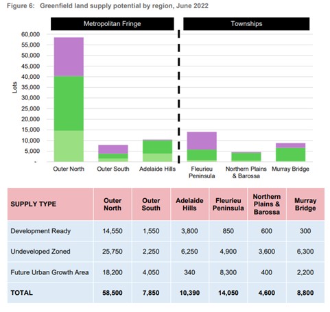
Source: Land Supply Report for Greater Adelaide – Residential (July 2023)
Will the Joint Amendment rezone valuable farming or arable land for housing?
The Affected Area subject to the Joint Amendment is located wholly outside of the Environment and Food Production Area (EFPA) established under the Planning, Development and Infrastructure Act 2016 in 2017.
The EFPAs were introduced to protect vital agricultural lands surrounding metropolitan Adelaide from urban encroachment.
What investigations were undertaken to prepare the rezoning proposal?
A number of investigations were taken to prepare the rezoning proposal ranging from ecological assessments to cultural and heritage surveys, air quality monitoring and traffic assessments, through to stormwater management.
A summary of these investigations is provided in the draft Joint Amendment document which has been released for consultation.
For a full list of investigations, including downloadable copies of reports, visit the PlanSA website: plan.sa.gov.au/en/ca/sellicks-beach-growth
If the land is rezoned for residential development what kinds of houses will be built?
The proposed rezoning of the affected area in Sellicks Beach will support a variety of housing types and densities. The Master Planned Neighbourhood Zone to be applied to the affected land at Sellicks Beach envisages a variety of low-medium and medium-high density types of housing, depending on the location.
The proposed ‘Activity Centre’ will be surrounded by medium-to-high density housing, to provide easy access to local services such as retail, medical, community and recreational facilities.
Medium density housing, which could include detached homes, semi-detached houses, townhouses and row houses, could also be located near public open space.
Residential neighbourhoods would consist of lower density housing.
About 15 per cent of homes across the Sellicks Beach Growth Area are anticipated to be affordable homes, meaning the maximum sale price is $495,000-$569,250 and rentals are offered at less than 75 per cent of the market rate. For more information, visit housing.sa.gov.au/affordable-housing/affordable-homes.
How will you ensure that the land is not developed as ‘wall to wall’ housing?
Sometimes ‘wall to wall’ housing is appropriate, such as for terrace housing located in areas of higher density, close to activity centres and open space.
In other areas where lower densities are envisaged, minimum setbacks between dwellings will apply (e.g. not wall to wall).
The proposed Master Planned Neighbourhood Zone also allows use of Building Envelope Plans (BEPs), which will assist in guiding appropriate boundary-to-boundary development. Council will determine how these BEPs are finalised.
A good example of this is the successful negotiation of the first BEP at Aldinga by council with the developer of this site.
Parts of the Area Affected at Sellicks Beach will also be developed for public open space as shown on proposed Concept Plan 163 – Sellicks Beach: Land Use. There may also be more areas of open space negotiated with council through the land division assessment process.
How will development be managed to reduce visual impact? How will developer/s be required to reduce the amount of cut-and-fill (e.g. excavation of land), retaining walls, and determine colours of external walls and roofs?
The proposed Master Planned Neighbourhood Zone will facilitate a planned approach to future development in the proposed area. It seeks to ensure future developments are sensitively designed and located to minimise visual impacts while taking advantages of significant and far-reaching views offered by the elevation of the land in the proposed area.
In response to the topography of the land, it is likely that lower density development will be provided on sloping land to respond to any landscape constraints and minimise the extent of cut and fill. Medium density development is likely to be more feasible on flatter sections of the land. The composition of future development will be determined at the land division stage and will be subject to assessment by the council.
The Planning and Design Code does not dictate colours of new homes, but design policies guide the articulation and design of dwelling facades, which can include the use of a mixture of materials.
Changes to the National Construction Code (NCC) including new sustainability measures were also implemented across South Australia on 1 October 2024 and address issues such as wall and roof colours.
Changes to the NCC include the introduction of mandated 7-star Nationwide House Energy Ratings Scheme (NatHERS) ratings on residential homes and 5-star National Australian Built Environment (NABERS) ratings for all new commercial developments.
If the rezoning proposal is successful how long would the houses take to build?
This Joint Amendment only seeks to change what the Affected Area of land could be used for in the future. Therefore, proposed housing, land division and associated infrastructure projects arising from the change of zoning though this Joint Amendment will require a development application to be lodged and approved by the relevant Planning Authority (most likely council) under a separate process.
Once land is rezoned it typically takes a few years to bring land to market and for development to occur (due to design and approval processes, construction and sales etc.).
Under the current South Australian Housing Roadmap, it is proposed that the new development at Sellicks Beach be construction ready by December 2029, which would mean that the first houses would be built in 2030.
What new or additional infrastructure and services will be provided to support a future housing community and who will pay for it?
A Basic Infrastructure Scheme (the Scheme) will be developed to ensure the infrastructure needed to support future growth in Sellicks Beach is well understood and planned for.
Infrastructure schemes create a coordinated delivery mechanism for basic infrastructure such as roads, intersections and bridges and stormwater management, and may include services such as water, wastewater and electricity.
The scheme will be developed between local government, landowners, utility providers and state government agencies and will set out the infrastructure required, when it will be delivered and the funding arrangement to ensure infrastructure is available in line with development of the land.
The delivery of social infrastructure, such as recreation and other community facilities and services, will be negotiated with council.
Other areas of public open space, distributed as a network of neighbourhood, local and pocket parks, will also be provided, subject to assessment of the council in a future land division process.
Find out more:
What walkways and shared paths are included in the plans to connect the new and existing community?
The scale of the area to be rezoned and its closeness to existing walking and cycling networks provides significant opportunities to connect new public open space with the wider network.
This includes strengthening east-west links to premier trails such as the Coast Park Path and any shared use paths developed as part of the current Main South Road duplication project (Stage 2) to Sellicks Beach, which will link to key destinations in the wider area.
Proposed Concept Plan 163 – Sellicks Beach: Land Use shows the potential shared use path network, view the plan in the documents on YourSAy.
How has the impact on services such as healthcare, public transport and education been considered if the community of Sellicks Beach grows?
There are numerous medical facilities and allied health facilities within the general vicinity of the rezoning area, many of which are co-located with key centres. The nearest medical centre is located 6 kilometres from the rezoning area, The Rowley Road Clinic at Aldinga, while a GP clinic is available about 8 kilometres from the rezoning area on Old Coach Road at Aldinga.
A new population at Sellicks Beach is expected to provide opportunity for an additional medical centre-GP clinic, which the proposed Master Planned Neighbourhood Zone can accommodate.
Public hospital services are provided at Noarlunga Hospital (approximately 24km or 24 minutes by car from the rezoning area) or Flinders Medical Centre (approximately 40 km or 34 minutes by car from the rezoning area). The Noarlunga Hospital is currently undergoing a major expansion, which will include an additional 48 beds and the Flinders Medical Centre is also currently undergoing a major expansion/upgrade.
Detailed social infrastructure investigations provided as part of the Joint Amendment have examined in detail the provision of the following facilities and services to the local area:
These investigations conclude that there is adequate social infrastructure available in the local and broader area to accommodate the proposed new housing development at Sellicks Beach. This is due to the proximity of the Noarlunga Regional Centre to the site as well as the location of numerous community facilities and private and public schools in the local area – particularly at Aldinga. However, the investigations do acknowledge that there may be scope for an additional primary school (by 2041) if required, but also notes that there is existing surplus capacity in existing local schools and ability to expand schooling ground to accommodate future growth.
The investigations also flag that there have already been some initial discussions with council in relation to the social infrastructure in this area given the growth predicted.
How will water and sewage/wastewater be managed and are there any plans for upgrades to systems or services to connect the future and existing community to existing water treatment plants/wastewater treatment plants?
Preliminary discussions have occurred with SA Water to understand the availability of water and sewer infrastructure in the locality to service the envisaged development.
In terms of water supply, this is currently sourced (for Sellicks Beach) from the Myponga Water Treatment Plant.
Envisaged growth at Sellicks Beach will therefore necessitate upgraded connections to the Myponga Water Trunk main and the provision of additional water storage tanks.
Sellicks Beach wastewater is currently treated at the Aldinga Wastewater Treatment Plant (WWTP) so the envisaged growth of Sellicks Beach will also trigger an upgrade of the Aldinga WWTP facility and will require upgrades of the associated wastewater network infrastructure.
The proposed Infrastructure Delivery Scheme will look to align delivery plans for water and sewage infrastructure.
How will the trees and plants on the land and important environmental areas nearby, such as the Aldinga Washpool, be protected?
Structure planning for the growth area has been informed by the outcomes of an ecology and tree assessment, which included:
The Regulated and Significant Tree Overlay from the Planning and Design Code applies to the area proposed for rezoning to ensure conservation of regulated and significant trees. It aims to preserve these trees for their visual and environmental benefits and mitigate tree loss, and to guide the assessment of proposals for their removal where necessary.
A stormwater management strategy has been developed which identified the new infrastructure required to manage stormwater and protect sensitive downstream environments such as Aldinga Washpool. Elements of the stormwater management strategy have been identified on the proposed Concept Plan 164 – Sellicks Beach Infrastructure included in the consultation documents, including stormwater treatment areas and detention basins. To view the concept plan, see the document section on YourSAy.
Read more about the environmental considerations in our Environmental Fact Sheet for the Sellicks Beach Growth Area Joint Amendment available for download on YourSAy.
How will any increases in traffic and noise be managed to minimise the impact to existing residents?
Traffic investigations undertaken for this Joint Amendment include an assessment of potential traffic volumes generated by future development in the proposed area (i.e. northern and central/southern portions) during peak commuter periods and the likely distribution into the adjacent road network.
This includes consideration of the distribution of traffic to/from Main South Road as well as other key adjacent lower order roads such as Sellicks Beach Road and Justs Road. The assessment also includes modelling of potential impacts on key intersections in the locality and has considered potential future access arrangements to the proposed area.
The analysis undertaken indicates that the above additional traffic flows can be adequately accommodated subject to future infrastructure upgrades as referred to in the question below.
In terms of managing noise impacts from any existing external businesses/operations, a 35-metre buffer is proposed to be included to the west of the existing Berg Herring Winery, located along Sellicks Beach Road. There will also be a 10-metre landscaped buffer provided along the eastern boundary of the area affected to provide an appropriate interface with adjacent rural land located next to Main South Road. Both buffer areas are identified in proposed Concept Plan 163 – Sellicks Beach: Land Use available on YourSAy.
What are the plans for transport upgrades both within and outside of the proposed site/area to improve existing intersections and access to Main South Road? Will new access be provided to Main South Road?
Traffic/road network improvements are currently being determined and will be finalised through the proposed Basic Infrastructure Delivery Scheme process. (See the frequently asked question on this above).
Investigations (to date) confirm that adequate access can be provided for future development in the proposed area subject to further discussions with the Department for Infrastructure and Transport (DIT) and council in relation to future intersection upgrades and proposed new access to the proposed area. These discussions are currently progressing with details to be finalised through the proposed infrastructure agreement process.
Proposed Concept Plan 164 – Sellicks Beach: Basic Infrastructure illustrates some of the infrastructure required to manage traffic and is available to view on YourSAy.
What is the Mass Transit Investigation Corridor?
The Department for Infrastructure and Transport is undertaking planning and investigation works required to explore opportunities for the extension of public transport services to the identified growth area of Sellicks Beach.
The corridor is shown in the Greater Adelaide Regional Plan at a conceptual stage only, with further planning and investigation work required before any future mass transit options can be determined.
The corridor of land that will be preserved for any future mass transit project was determined to allow for the future provision of accessible, efficient, and equitable transport options for the community and wider Fleurieu region, providing safe, accessible, and connected options for different travel modes (public transport, walking, cycling and private vehicles).
The Department will continue to work collaboratively with key stakeholders around future land use and transport opportunities.
Visit www.dit.sa.gov.au/garailextensions for more information.
What are the outcomes of the air quality monitoring at Sellicks Beach and how has this been considered in the rezoning proposal?
In November 2024, the Department for Housing and Urban Development (DHUD) began an Air Quality Monitoring and Assessment to better understand environmental conditions in the area. This is part of the broader planning work for the proposed rezoning.
The Department has an independent consultant conducting the monitoring as part of the assessment. A cross-government working group including SA Health, the Environment Protection Authority (EPA), and the Department for Energy and Mining (DEM) is being led by DHUD.
Early results from the monitoring period between November 2024 and April 2025 show that more time is needed to better understand the air quality in the area. Monitoring will continue until the end of April 2026.
Consequently, the Joint Amendment will apply the new Coordinated Development Overlay across the affected area, which acts as a holding mechanism to defer urban development until air quality monitoring and assessment is complete and infrastructure agreements are in place.
More information on air quality monitoring and findings to date, information including a fact sheet, frequently asked questions and the preliminary air quality monitoring report is available on PlanSA at plan.sa.gov.au/en/ca/sellicks-beach-growth
How has open space and areas for recreation been considered in the proposal?
Based on the local provision and service standards for open space, it is anticipated that at least 12.85 hectares of public open space, distributed as a network of neighbourhood, local and pocket parks, will be provided to support the community.
The proposed zoning to Master Planned Neighbourhood Zone will ensure a planned approach to providing open space in the proposed area and will be subject to assessment by the relevant authority as the land is developed.
Proposed Concept Plan 163 – Sellicks Beach Land Use, included in the consultation documents, identifies the likely provision of open space corridors associated with Sellicks Creek and other watercourses through the area.
How have cultural perspectives of Traditional Owners of the land been considered in the proposal?
As part of its investigations to prepare the Joint Amendment, the Department for Housing and Urban Development has undertaken a search of the Aboriginal Heritage Register and can confirm that no sites of significance have been identified in the proposed area for housing development.
Aboriginal sites or objects are protected by the Aboriginal Heritage Act 1988. The Code does not contain information about the location of sites or objects of significance to Aboriginal heritage.
The Department’s Aboriginal Cultural Heritage Assessment Investigations have concluded that land in the proposed area is within a Native Title determination area. On this basis, the registered Native Title body corporate – Kaurna Yerta Aboriginal Corporation – will be informed and consulted on the proposal to rezone the land, out of respect for the Traditional Owners of the land.
Where can I view hard copies of the Joint Amendment and find more information?
View the draft Joint Amendment, as well concept plans, fact sheets, frequently asked questions and copies of reports for the investigations undertaken in the documents section on YourSAy. You can also:
Hard copies of the draft Joint Amendment are available to view during standard opening hours at:
How can I provide feedback on the Joint Amendment?
You can submit feedback by:
How will my feedback be considered in any updates to the draft Joint Amendment?
All feedback submissions are acknowledged, and at the end of the consultation a summary of the feedback received, known as a ‘what we heard’ summary, is prepared and sent to everyone who made a feedback submission.
All feedback received during the 6-week consultation will be considered in any updates to the draft Joint Amendment. To be considered in any updates, the feedback needs be within the scope of what can be influenced in the consultation on the Joint Amendment.
Aspects that can be influenced in the Code changes include: how and where the proposed zone, subzone and overlays are applied across the land for rezoning, and content on the proposed Concept Plans, including the location of the activity centre, shared use paths, landscaped buffers, new roads, road upgrades and stormwater infrastructure.
In the Greater Adelaide Regional Plan change, the community can influence the proposed wording of the recommendation introduced.
An engagement report, which includes copies of all feedback submissions received during the consultation, is prepared and submitted to the Minister for Planning to consider when making a decision whether to adopt the Joint Amendment.
The engagement report outlines how the engagement for the consultation met the principles of the Community Engagement Charter. It also describes how the feedback received was considered in any updates to the draft Joint Amendment.
Once the Minister has made a decision on the Joint Amendment, a copy of the engagement report will be available with the finalised Sellicks Beach Growth Area Joint Amendment on PlanSA.
Why is a change to the Greater Adelaide Regional Plan required?
The Greater Adelaide Regional Plan (the Regional Plan) needs to be updated to reflect that the Sellicks Beach Growth Area can only be developed for urban purposes once the current air quality monitoring and provision of infrastructure are resolved to the satisfaction of the Minister for Planning.
It is therefore proposed to change the Regional Plan to include a new recommendation that states that the proposed Coordinated Development Overlay (which acts a holding mechanism for urban development) can only be removed from the Affected Area following the satisfactory resolution of the above matters.
The proposed amendment to the Regional Plan will therefore enable a future complying change to be made to the Code to remove this Overlay.
What is a Complying change and how will it be applied to the Sellicks Beach Growth Area Joint Amendment?
A Complying Change is a streamlined pathway to amend the Planning and Design Code that is consistent with a recommendation made in a regional plan.
The Joint Amendment is amending the Greater Adelaide Regional Plan to insert a new recommendation to allow residential development at Sellicks Beach Growth Area to proceed once air quality has been resolved and infrastructure commitments have been secured.
A Complying Change process can be completed by the Minister for Planning once these two conditions have been resolved.
